
Nubs at the Sea of Stone
Felsenmeer (Lautertal)
Das Felsenmeer auf dem Felsberg oberhalb von Lautertal-Reichenbach im Vorderen Odenwald ist eine Felsenlandschaft aus dunkelgrauem Quarzdiorit (genauer ein Hornblende-Biotit-Diorit),[1] die durch Wollsackverwitterung entstand.[2] Das Felsenmeer wurde bereits von den Römern und später durch die örtlichen Steinmetze zur Steingewinnung genutzt. Die Steinmetzen bezeichneten ihn als „Felsberg-Granit“, der heute nicht mehr abgebaut wird. Heute ist das Felsenmeer ein beliebtes Naherholungsgebiet und Ausflugsziel für Familien und Wanderer. Es liegt innerhalb des Naturschutzgebiets „Felsberg bei Reichenbach“. Am oberen Ende des Felsenmeers befindet sich eine kleine Quelle, deren Rinnsal zwischen den Felsen hinab ins Tal fließt und schließlich im Graulbach mündet.
The Felsenmeer on the Felsberg above Lautertal-Reichenbach in the Vorderen Odenwald is a rocky landscape of dark gray quartz diorite (more precisely a hornblende biotite diorite),[1] which was formed by weathering of wool sacks.[2] The Felsenmeer was already used by the Romans and later by the local stonemasons for stone extraction. The stonemasons called it “Felsberg granite”, which is no longer quarried today. Today the Felsenmeer is a popular local recreation area and destination for families and hikers. It lies within the nature reserve “Felsberg near Reichenbach”. At the upper end of the Felsenmeer there is a small spring, the trickle of which flows between the rocks down into the valley and finally flows into the Graulbach.
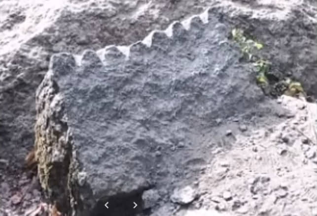
Say[edit | edit source] The legend of the Felsenmeer in Lautertal is about two giants who lived in the Reichenbach area. One on the Felsberg (Felshocker), the other on the Hohenstein (Steinbeisser). Their “giant kingdoms” were separated by the Lautertal (Odenwald). When they quarreled, they threw boulders at each other. The “Steinbeisser” had an advantage, he had more throwing material. So it was that “Felshocker” was soon buried under the blocks; it is said that he can still occasionally be heard roaring underneath. The rock face of the Hohenstein is said to be the last house wall of the other giant. This is how the formation of the Felsenmeer was explained in the vernacular.[3] Geological formation process[edit | edit source] Frost and water are important factors in the weathering of rocks The oldest rocks in the crystalline Odenwald are probably more than 500 million years old. In the Palaeozoic period, 380 to 340 million years ago, two large primeval continents shared the planet. As a result of continental drift, the two major continents moved towards each other and began to merge into the supercontinent Pangea. The Odenwald is the result of the subduction of a smaller continent as the two supercontinents merged. At that time, the area of today’s Odenwald was roughly at the level of the equator. The continent pushed into the subduction zone was melted in the zone of the upper mantle. The rock melts now slowly rose from the depths, cooled down in the earth’s crust and formed plutonites.[4] Fracture due to surface expansion The Felsenmeere on Felsberg consist of quartz diorite. This crystalline rock belongs to the granitoid group and consists of the minerals feldspar, pyroxene, hornblende and quartz.[5] The quartz diorite, which was formed at a depth of about 12 to 15 kilometers, took a good 10 million years to cool down. Rock bodies that cool shrink and crack. In the early Mesozoic, the Odenwald was flooded and covered by deposits due to a global rise in sea level. It lasted until the Tertiary to remove the overburden, which was several kilometers thick. The rise of this massive quartz diorite intrusive to the surface was aided by the collapse of the Rhine Graben about 50 million years ago and the associated bending of the graben edges. Cracks and chasms in the rock continued to deepen, eventually dividing the rock into cuboid blocks that were now exposed on the surface to the intense chemical weathering of the subtropical climate. Weathering caused by permafrost, for example The weathering reached even deep-lying rocks and caused the disintegration of the boulders, mainly at the edges. Weathering debris, a mixture of gravel and clay minerals, gathered around the blocks. During the last Ice Age around 12,000 years ago, the Odenwald was in a zone of permafrost and was not covered by the ice sheet. In the warmer seasons, the ground could thaw a bit and water washed around the boulders. The granite grit was eroded and the water collected in the cracks and crevasses froze in the winter months. With the receding of the frost line at the end of the Ice Age, the now exposed blocks began to move, slid down the valleys and formed the Felsenmeer. The weathering process that gives the rock blocks their typical appearance is known in geology as wool sack weathering.[6] The Roman workpieces at the Felsenmeer[edit | edit source] Roman work piece, the ship The unique selling point of the Odenwald Felsenmeer are the Roman workshops. The Romans left almost three hundred unfinished or damaged workpieces on the Felsberg, spread over 15 workshops. Since almost no tools, inscriptions or objects of everyday use were found, the time and duration of the Roman presence can only be determined approximately. After a detailed analysis of the material, the activity of the Romans at the Felsenmeer is narrowed down to the second to fourth centuries. The stone splitting technique with iron wedges was already very sophisticated in Roman antiquity. To do this, a series of conical holes (so-called wedge pockets) are worked into the stone. Wedges are then driven in. However, the splitting effect is not generated by the cutting edge of the wedges, but exclusively by the flank pressure of the wedges against the wedge pocket. It is therefore important that there is as complete a contact as possible between the flanks of the wedge and the side surfaces of the wedge pocket. This is one of the reasons why wedge pockets are usually very carefully chiseled out. An effect feared by the stone cutters are the so-called stitches. These are defects in the structure of the material that do not run through the entire block. If a stitch was discovered just before the completion of a work piece, this usually led to the work piece being abandoned — as in the case of the so-called coffin or very clearly recognizable in the case of the altar stone, which very clearly shows an unwanted splitting off. This may also be the reason why the completely finished giant column remained on site. Experts believe that the pillar’s internal structures did not allow it to be accurately dissected. Retrieving the giant column from the Felsenmeer undamaged would be a difficult task, even with 21st-century technology. Sawing with toothed saw blades is only possible with very soft rock. Stone sawing is usually a grinding process: the horizontally oscillating saw blade grinds a narrow groove out of the material with the addition of quartz sand and water. The sawing technique has the advantage that the natural tendency of the rock to split does not have to be taken into account. For the Felsberg one can assume that mobile saws were used. Since the Felsberg was an all-encompassing workshop, the blocks were not taken to the saw, but the saw was set up above the blocks. The probable sawing capacity was 5 mm lowering per hour with a cutting length of 1 m. Conservation[edit | edit source] Rock ecosystem = boulder heap with moss growth and dead wood The Felsenmeer registers more than 100,000 visitors a year, who visit the Felsberg area mainly on the weekends. Conservationists criticize that visitor management measures have so far had no effect. The damage caused by beaten paths, rubbish and torn-off foliage (branches, fallen bushes) is unmistakable in the area of the main flow of visitors and the core area of the Roman workshops (giant column, pyramid, altar stone) and has also been documented in various official reports for many years. With the registration with the European Commission by the state of Hesse in 2000, the Felsberg nature reserve near Reichenbach is also a Natura 2000 area. This means that the Felsberg and with it the Felsenmeer are part of the Europe-wide ecological network that is intended to protect the conservation of biological diversity better than before. A description of the FFH area Felsberg (No. 6218 – 301) is documented in the standard data sheet excerpt of the Hessian Ministry for the Environment, Climate Protection, Agriculture and Consumer Protection (HMUKLV)[7]. Six habitat types for which reporting is required under the Habitats Directive are listed. The importance of the six habitat types is presented and the conservation status has been assessed[8]. 8150 siliceous screes from the mountains of Central Europe (6.72 ha); Conservation status: average or limited 8310 caves not developed for tourism (< 1.68 ha); Conservation status: average or limited 9110 Forest-Hainsimsen-Buchenwald (Luzulo-Fagetum) (38.64 ha); Conservation status: average or limited 9130 woodruff-beech forest (Galio odorati-Fagetum) (85.68 ha); Conservation status: good 9180 ravine and hillside mixed forests Tilio-Acerion (1.68 ha); Conservation status: good 91E0 Alluvial forests with Alnus glutinosa and Fraxinus excelsior (Alno-Padion, Alnion incanae, Salicion albae) (<1.68 ha); Conservation status: good This assessment also states that the destruction of the soil flora by the streams of visitors, footpaths and soil compaction on more than 2 hectares endangers natural tree regeneration.[9] Sights[edit | edit source] Geopark Information Center of the municipality of Lautertal The Geopark Information Center of the municipality of Lautertal, which deals with the geological history of the Geopark, the formation of the Felsenmeer, Roman history, the natural stone industry and the legendary treasure from the Odenwald, was opened in spring 2007. “Felsenmeer Information Center” has been a registered word and picture trademark of the Lautertal municipality since February 2008. The Ohlyturm, a 27 m high observation tower made of granite, marks the highest point of the Felsberg. At 514 m above sea level, its summit is only 3 m lower than that of Melibokus. Today, the Ohly Tower is considered a particularly striking example of the romanticizing historicism of the 19th century, which was modeled on medieval castles and other fortified structures. The tower is registered as a cultural monument according to § 2 paragraph 1 of the Hessian monument law. However, the tower is not open to the public, comprehensive renovation measures are necessary to enable visitors to have an all-round view from the tower platform again. The Siegfried spring at the foot of the Felsenmeer is considered one of the possible crime scenes of Siegfried’s murder in the Nibelungenlied. Special Roman Workpieces[edit | edit source] The Giant Column in 2007 Domstein at Trierer Dom in Trier The giant column is 9.3 m long and weighs around 27.5 t. She is finished. Hardly any piece of rock was described in more detail and examined in more detail. Three saw cuts that have been started indicate that an attempt was made to dissect the column and remove it. On May 1, 1980, the giant column was so badly damaged by a fire that a piece broke off.[10] The dome stone at Trier Cathedral is a remnant of the giant column at the Felsenmeer[11]. Three pictured column shafts made of Felsenmeer diorite (grey) on the fountain house in the inner courtyard of Heidelberg Castle. The right column is probably made of Lahn marble. Furthermore, five pillars were used on the fountain house in the inner courtyard of Heidelberg Castle, in Mainz on the water basin on Schillerplatz and on the Oppenheim war memorial.[1] Altar stone with wedge incisions, the smooth cut, breaking point Panel-like workpieces were wedged off the altar stone by first making saw cuts in panel thickness into which the splitting wedges could be inserted. The stone lifted off nicely from the end of the saw cut sideways. Two saw cuts were scheduled but not completed. pyramid The technique of splitting while lifting (horizontally) can be seen very well on the pyramid. From an egg-shaped block, the head side was split up to the level of a stitch and then while lifting. At 12.35 m, the ship is the workpiece with the longest continuous work edge. The wedge splitting is neatly executed, even if the mass of the rock broke away a significant part of the material with it, creating the “ship’s prow”. The coffin was rendered useless by an undercut in wedge fission, where the split followed the structure of the rock. The side surfaces are partially machined. The circular plate protrudes conspicuously from the floor area and has a very evenly finished surface. Creating a circular piece was a very ambitious goal. However, an undercut at about 7 o’clock meant the task. Creation of nature: crocodile rock Other sights[edit | edit source] Creations of nature such as the giant armchair on the edge of hiking trail no. 4 or the crocodile on the edge of hiking trail no. 3. The exact location can be found on the information boards on site. The Borstein is the beginning of a rock formation (gangway) that continues on the Hohenstein on the other side of the valley. The Borstein (4 m to 8 m high) and the Hohenstein (8 m to 14 m high) are ideal beginner rocks for climbers and alpinists. Climbing and bouldering is allowed and there are a few hooks, especially the Hohenstein is suitable for climbing.[12] The geological-historical nature trail is part of the Bergstrasse-Odenwald Nature Park. In 1985 it was created on a stretch of about 2.5 km with 16 information boards. It begins at the Römersteine car park. Educational trail of the NABU bird protection group Reichenbach; Start from the Talweg or Borstein car park. The owl tower — an old electrical substation — was taken over by the NABU bird protection group in 1979 and converted into a haven for bats and owls, location: parking lot at Talweg.
Keine Kommentare